Sunday, March 24, 2013

New boots!


The Danner Talus hiking boots I bought last year just aren't working for me. They keep giving me blisters. So I finally decided it was time to replace them. I bought a pair of Merrell Moab Ventilator shoes and tried them out on the trail this weekend.

Before I talk about my hike: I really like the shoes. They aren't waterproof like the Danners, but I can always wear my Danners if I know I'm going to be on a really wet trail. They don't have as much ankle support, but they're much lighter and I think will do well this summer.

We had cool and rainy weather this weekend. Saturday I hiked the River Bluff trail above the dam, which I posted about last spring; today I hiked about three miles in the watershed. Both days it was around 45-50 degrees. I decided to not bother with a jacket and instead just hiked faster. I stayed reasonably warm, even today when it was drizzling the whole time (I did wear my awesome rain hat).

The undergrowth is getting green, and wildflowers are blooming. The bloodroot is still blooming (one of my favorite flowers, and one of the earliest to bloom), and I saw Dutchman's breeches, a few early trout lilies, and lots more. The trilliums are coming up and some are starting to develop buds, and I even saw the first mayapples coming up. They remind me of newly hatched butterflies at this stage, their pair of umbrella leaves crumpled and wet-looking.

Since it was raining today, I didn't bring my camera. Well, I did, but after attempting to take one picture through the plastic bag I'd put it in, I decided to leave it in the car after all. I wished I had it before I'd gone very far, since the rain slacked to a drizzle and I could have taken the camera out of the bag long enough to take pix safely. I almost went back to get it but didn't, and I kicked myself for not doing so the entire hike. The rainy light brought out all the warm browns and golds of the woods, and the mosses and ferns and underbrush and weeds and wildflowers all practically glowed green. Mist hung between the trees.

The boots did great for me on Saturday. I wore wool hiking socks with them, but today in the spirit of inquiry I wore regular cotton socks instead. The boots still did well, but I did end up with two sore spots on the insides of my heels where a blister might have developed if I'd gone much farther. So from now on I'll wear hiking socks, which are more comfortable anyway.

Here's the picture I took today that convinced me I should leave my camera behind. It looks like I used some kind of Photoshop filter on it, but that was just the camera focusing on the plastic instead of the view.

Sunday, March 17, 2013

Bird Mountain, Frozen Head State Park

The weather turned so warm and sunny yesterday, and the rain held off, that I decided to go hiking. At first I'd intended to hike River Bluff, a 2.7 mile loop that's pretty close to where I live. But I decided to go somewhere I hadn't been before, and a quick online search turned up Frozen Head State Park. I hadn't been there since I was a kid. I decided on the Bird Mountain loop, except that it's not actually a loop. Here's a good page about Frozen Head--it's for birders, but it's got better directions to the park than other sites. If you do visit, though, keep in mind that Flat Fork Road is NOT marked. There's a sign for the park but it's easy to miss. If you're me. You'll know you're on the right road when you pass a huge prison complex.

It took me about an hour to reach the park (okay, an hour and a half but that's because I missed the turn and drove on and on to Sunbright, where I finally turned around with a heavy sigh and went back). I reached the park office around 1:30pm and stopped to pick up a map. There weren't any outside, but the office was open so I went in. Unfortunately they didn't have any trail maps, although it's possible I just didn't see them. I picked up a brochure with a very simple map, mostly of the camping/picnic areas. There are bathrooms in the office--real ones that you can flush!
above: a nice trail seat, polished smooth from hundreds of tired bottoms

The directions I'd found online said to park at the office and walk up to the trailhead, but I went on to a trailhead parking lot about a quarter mile along the road. There are a bunch of trails that start from there, and more bathrooms, but I walked up the road and into the camping area, then up to the gate that leads to a fire tower. Turns out there's a tiny parking lot next to the gate just for hikers--only three spaces, but they were empty when I got there and still empty when I left. I wish I'd known.

Anyway, it was a glorious day, over 70 degrees, and this was the first weekend the park was open for camping. It was packed, with little kids running around and adults grilling out, and groups of hikers returning from various directions. I passed several bunches of hikers before I actually reached the trailhead and figured Bird Mountain Trail would be busy. But I only saw one group on the trail, about half a dozen guys who were returning from the summit when I was just starting up. I noticed they gave me "oh man, you poor thing" looks but it wasn't until I was well up the trail that I understood why.
left: Big Cove Branch creek, just before you reach the trailhead

The internet tells me there are 14 switchbacks going up Bird Mountain. I started out trying to count but lost track, so I'll just have to trust that 14 is correct even though it felt more like 30. The day before, I'd taken a short hike up Ridgecrest Trail in the Norris Watershed, which is the steepest trail I habitually hike. Well, Bird Mountain is like 14 Ridgecrest Trails one after the other. (Actually I hiked Ridgecrest again today and I do think it's steeper, but the steep part is only about a third of a mile long and Bird Mountain is about two miles to the top.)

I didn't hurry myself. It's not like I'm in training for anything; my goal in hiking is just to have fun, get some exercise and fresh air, and appreciate nature. I kept having to rest more and more often. That was good in a way, though, since that gave me plenty of time to look around. There was also a near-constant breeze, sometimes very strong, that kept me from getting too warm, and I could listen to the wind in the treetops and the screek of tree branches rubbing together. I heard birdsong in the mountain laurels but didn't actually see any birds or animals.

There's a lot of trail that comprises Bird Mountain. I only took one small section of it, the two-mile climb up to Castle Rock. I could have continued another half mile to a camp site but I didn't see the point. It meets the Cumberland Trail at the top of the ridge, so I can tell people I've hiked part of the Cumberland Trail even though "part of" in this case means about 20 yards.

I had to stop after a mile and a half or so and put moleskin on my right heel. I hadn't tied my right boot tightly enough and it had rubbed blisters on my heel in two spots. The reason I hadn't tied it very tightly was a failed attempt to avoid reopening a different blister that same boot had given me on my ankle. It always gives me a blister on that ankle. When I got back to my car I discovered that I'd also gotten a blister on my big toe knuckle, whatever it's called. So I definitely need new boots sooner rather than later, unfortunately.

But despite my blisters, I enjoyed the hike. There wasn't a whole lot to see until I reached the top, though: no points of interest like creeks or sinkholes, abandoned buildings, things like that. Just 42 switchbacks going up and up and up. I took three pictures of a huge fallen tree that looked like it had caught fire too--the branches were all blackened--because really there wasn't a whole lot else to hold my attention.

Of course, castle rock was worth the climb. It's magnificent. I climbed around on it for a few minutes, taking pictures and enjoying the view of the ridgetops all around, then sat down and ate a peanut granola bar (which was so sweet I might as well have packed a Snickers) and drank a lot of water. It felt good just to sit and let the wind dry the sweat on my face. I thought I'd at least see someone at the top of the ridge, but not a soul. Not even a bird.

While I rested, I took out my phone to check the time. It was 3:20, so it took me almost two hours to climb two miles. But the trip down was a lot easier. In fact, it went so fast that I was kind of disappointed. For one thing, I hate to backtrack. For another, the trail is steep enough that most of my attention was on my feet so I wouldn't take a misstep and tumble down all 63 switchbacks.

left: there were a lot of squeezes among the rocks of castle rock. I mostly didn't squeeze through any of them because I have a morbid dislike of bugs falling down the back of my shirt or getting in my hair.

I reached my car around 4:40 and stripped off my boots and socks first thing. Clouds were moving in but the temperature had climbed to almost 80 degrees, so I was definitely glad to get my wool socks and heavy leather boots off.

I will definitely be back to Frozen Head, but I don't think I'll hike Bird Mountain again. There are plenty of other trails to explore, though.

Below: view from my perch on castle rock, where I rested and snacked

Tuesday, March 12, 2013

Big Ridge again

I had such a good time on my last hike to Big Ridge State Park that I went again on Sunday. It was just past noon and gloriously sunny, about 60 degrees when I got there and almost 70 when I got back to my car.

This time I decided to find the graveyard on Ghost House Trail that I missed last time. I took Lake Trail from the parking lot, crossed the dam and turned right, then took the eastern loop of Ghost House Trail. From the top of the loop I took the southerly section of Big Valley Trail to the road, then crossed the road and picked up Chestnut Ridge Trail. That brought me to the cabins, and from there I had a surprisingly long walk back to my car. I think it worked out to five miles, or probably a bit under, and it was a lovely, easy to moderate hike.

At first I met a lot of people and dogs on the trail. But by the time I reached Ghost House Trail I might as well have been the only person in the park. I didn't see anyone else until I got back to my car. I didn't see any birds or animals (beyond the very common ones like squirrels), but I sure heard a lot of frogs. A few marshy spots sounded like Frogtown.
Above: Frogtown. Not a lot to see, but everything to hear.

I found the Norton Cemetery, too. If I'd only known last time, I passed within a matter of yards from it before. It's much smaller than I expected, a lot smaller than the Snodderly Cemetery I saw last time.

From the trail brochure I picked up at the park office: "According to locals...eerie and unexplainable events occur along [Ghost House] trail. ...[V]isit the sunken grave of Maston Hutch[e]son, who some think is responsible for these strange occurrences. NO HOUSE REMAINS." I was especially interested in Maston Hutcheson's grave, since Maston is a family name of my mother's family. It would be interesting to know if there's a connection somewhere in the distant past between Hutcheson and my grandfather, who went by his middle name, Maston.

I didn't see any ghosts. I didn't even get any spooky feelings. Some of the graves along the back of the little cemetery have fresh memorial markers although the people died in the 1920s and 1930s, so obviously the family is still in the area and still remember their ancestors.
Above: Why would you even name a little baby Harm unless you knew he would grow up to be an archvillain or a dentist?

I poked around the cemetery for a little while, then continued on my hike. At one point I hiked through a wide, sunny valley that made me feel really good for some reason. I took a picture and there's no real reason why I liked it there so much, but just thinking about it makes me smile. I think it was a combination of the open wood, the plentiful sun, and the low hills on either side of the trail. But really, I don't know. It was just a good place. It was like it was the opposite of haunted.

When I reached the road, I thought Chestnut Ridge trail would be obvious on the other side. But while there's a sign, the trailhead is actually well off the road on the other side of a grassy park area. There's a bridge over a creek; turn left on the other side of the bridge. The trail here got really steep, switchbacking up the ridge. I actually really enjoyed the challenge after what had been a fairly easy hike so far.

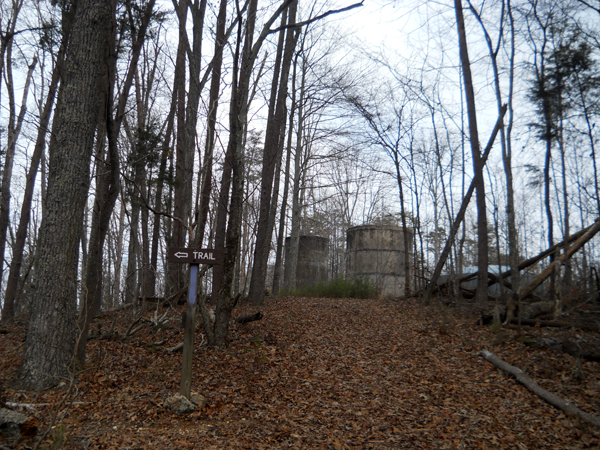
At the top there were a couple of old concrete structures that looked like some kind of silo, although silos aren't common around here, and a new structure that is probably a water tower for the nearby cabins.

The trail ended at a drive that loops around for people to get to the cabins. I'd never seen the cabins before that I remember, but they're quite nice. I was on pavement the rest of the way back to my car, which was hard on my feet after hiking all that way. I like my boots but they don't have a lot of padding. I think I'm going to have to invest in a really good pair pretty soon.

I had a good time, and there are still a few trails that I haven't seen yet at Big Ridge. I really appreciate that the trails are so well marked, too. I may go back in another month or so once the trees are green and the wildflowers are in full bloom.

Above: someone spent a lot of time and effort on this.

Sunday, January 13, 2013

Big Ridge State Park

It was 70 degrees yesterday, and although it kept drizzling and threatening harder rain, I went out to Big Ridge State Park anyway. I couldn't waste the good weather, and a little rain never hurt anyone. Besides, I have an awesome rain hat.

Big Ridge is only about ten miles away from my house, so I don't know why I haven't gone before. I hadn't visited the park since I was a kid. To get there, take Tennessee exit 122 off I-75; if you're coming from Knoxville, turn right off the interstate, otherwise turn left (away from Clinton/Oak Ridge). Drive 12 miles without turning anywhere and you'll see the Big Ridge sign on the left. The office is closed on the weekends, but there are maps available to take.

I grabbed a copy of the official Big Ridge brochure, which has a simple map, and a copy (actually two, because I didn't realize they were almost identical) of a more detailed map and directions. I was sitting in my car looking over the maps when I noticed a guy heading toward me, so although I doubt he would have bothered me, I drove off anyway just in case. When you're a woman hiking by yourself, the fewer people who know where you're going to be, the better (obviously that doesn't mean people you know).

I wasn't sure where the trailhead was, but I found it pretty easily. There's a big parking lot in front of the park office. If you drive to the end of the parking lot, near the water, you'll see a road running to the left of the lot. The trailhead is just across the road; there's a big sign and a posted map. I parked, put on my pack and rainhat even though it wasn't raining at the moment, and set off. Then I remembered to run back to my car and get the maps I'd just picked up.

My goal was to hike a five-mile loop. If you care enough to look at the map I linked to above (it's a pdf), you can follow along: start on Lake Trail, cross the Big Ridge Dam, turn left onto Dark Hollow Trail West, turn onto Big Valley Trail and follow it until it splits, take the Lake Trail branch and head back to the dam and then to the trailhead. That's exactly five miles. Only I didn't realize until I actually got there and was looking at the map that there's a loop within this loop that's called Ghost House Trail. I tried hard to figure out a way to walk that entire loop without backtracking or hiking more than five miles, and I couldn't. So I ended up taking the inner half of the Ghost House Trail loop, which meant that I inadvertently missed being able to visit the site of the old ghost house. Apparently the house is long gone but there's an old cemetery which is supposed to be haunted.

I set off on Lake Trail, which was muddy since it's been rainy most of the week, but which was in good condition and well-marked. That was true of all the trails at Big Ridge, incidentally. I was really impressed by how well they're marked, not just blazes but lots of large, readable signs. There's even a sign indicating that Dark Hollow Trail East is a dead end.

It was a brisk, easy hike to the dam. The dam is small and you can walk across it. There was a couple fishing from a boat on the other side of the dam, and we waved at each other. Then I turned onto Dark Hollow Trail West.

The trail followed along the edge of the lake--this is Norris Lake, but the opposite side of the lake from the part I can get to from the Norris Watershed. The water was low despite the rain, which left the red mud banks bare. I found this strangely fascinating and kept taking pictures, most of which I ended up deleting when I was processing them this afternoon.

Because of the drizzle, I thought I had the trails to myself. Unfortunately, I soon caught up with a couple with a little white dog. They were going too fast for me to overtake without a lot of effort, but too slow for me to be able to hike at my usual pace. I dawdled and took more pictures to give them room, since if there's anything worse than having to stay behind another group on the trail, it's having strangers start crowding you when you're hiking. But no matter how slowly I went, I kept catching up. When we reached a switchback going around a little inlet of the lake, the man said to me, "Want to go on ahead of us?" So I think they were slowing down on purpose so I could go around. I thanked them and stopped long enough to pet their little white mop-dog, which was only white on top--it was nothing but mud on its legs and tummy. Then I passed them and sped up to put lots of space between us.

I hiked fast and didn't take too many pictures. The trail here was mostly level, following alongside a creek that flowed down into the lake. Most of the year it's probably gorgeous, but in winter there wasn't a lot to see. I did startle a bird of some kind, maybe a pheasant? It burst out of a clump of underbrush in a clatter of wings, which made me jump.

Finally I came to the intersection and took Big Valley Trail. And almost immediately it got steep. Really, really steep. I felt like Frodo and Sam in the LOTR movies, going up and up and up, although fortunately at the top I didn't get ambushed by a giant spider. I had to stop to rest every so often, which was a good opportunity to take pictures. If I'd been with someone else, I would have sworn that I was only stopping to take pictures, not resting.


Up, up, up.

I enjoyed the climb, actually, partly because I like pushing myself a bit, partly because there was a cool wind blowing in my face that kept my glasses from fogging over. (I'm going to be getting contacts again soon, but I keep forgetting to make an eye doctor appointment.) At the top of the ridge I stopped to listen.

A far-off dog barked, and I heard the distant drone of a speedboat. Then even those sounds faded and there was nothing but silence and the occasional bird call. Bliss. On the way down--which was just as steep, and treacherously muddy so that I actually went slower on the descent than I had on the ascent--I stopped to listen to the silence every so often. Not that I needed to rest or anything.

I took the western half of the Ghost House Trail, which meandered through a much flatter area with at least one creek winding through it. The trail kept crossing the creek on various bridges, and for some reason I felt compelled to take a picture of every single bridge. They were all made of wood, and the wood was extremely slick from the rain. Even this one, though, which looks like it would collapse under a sparrow's weight, was completely sturdy.

While I'd been on the ridge, the drizzle had returned and it had gotten very dark. But the sun started to come out while I was on Ghost House Trail. It cheered me up--not that I was down or anything, but I was starting to get tired. At one point a pine had come down over the trail and hadn't yet been cleared away. I climbed over and decided to take a break, sitting on the damp trunk and drinking most of a bottle of water. I had brought my good Thermos full of water too, but ended up not needing it (possibly because I'd drunk my weight in iced tea at lunch before heading out to hike).

<--The thing that looks like a folded handkerchief sitting on the log is my map, which almost fell apart from hard use, rain, and sweat. I like to look at a map while I hike if it's convenient. Also, is that rain hat awesome or what?


It wasn't until I reached Lake Trail again that I realized I'd missed the Ghost House graveyard. Then I saw the sign for Norton Cemetery and thought that was it. I set off to see it. It's at the top of a small hill near the lake, although of course when the people were interred there was no lake. Norris Lake was created by the Tennessee Valley Authority in the 1930s, and all the residents were forced to move. I was surprised, though, that the graveyard seemed to have been in use right up into the 1920s. There were a lot more stones that were worn to illegibility or which had possibly never been carved, though, which argues that the graveyard had been in use for a long time. I don't know much about the history of the area. Apparently in October they have guided night hikes where the guides tell ghost stories, and I totally want to go to one of those this year if I can.

After that it wasn't far back to the dam. By then I was getting pretty worn out. I've been walking almost 2.5 miles almost every night since December, in an attempt to keep in shape for warmer weather, but there's a big difference between walking on pavement and hiking. Plus, I'd worn a new pair of wool-blend hiking socks I'd gotten at Target, and they just weren't thick enough. The bottoms of my big toes and a couple of other places on the bottoms of my feet were getting pre-blister sore from lack of cushioning. So although I'd had a great time and was very pleased with the hike, I was also glad to get back to my car.

I'll definitely be coming back to Big Ridge frequently this year.

Thursday, December 6, 2012

Observation Point, November/December

We've had some warm days recently, warm enough that I didn't want to stay inside. There's only so much yardwork that needs to be done this time of year, so I spent some of my outside time hiking up to Observation Point in the watershed. I know I've mentioned Observation Point here before; it's a lovely hike, and the quickest way to get there is from my house. A round trip from my front porch and back is probably a bit less than two miles and only takes about an hour to hike, and that's with me stopping at the top to take pictures.

Speaking of which, here are a few pix from the various trips I've taken in the last several weeks.
Above is the trail where it splits. Both trails go up to Observation Point. The right one is a bit less steep and slightly longer. I'm lazy and usually go up the right branch and come back by the other branch.
View from the bench at the top. I have a lot of pix of this view taken at various times of year. The above photo was taken in November.
And this is a view taken from the left of the bench. The river makes a U just below here; the dam is on the right side of the U (just visible in the first pic) and there's old farmland along the left. The above pic was taken in December.
There's a gazebo at the top of the hill, behind the bench. They're repairing it, obviously.

This time of year, the trails around Observation Point are crowded. The rest of the watershed is closed except to hunters, so hikers, bikers, runners, and horseback riders all squeeze into the strip of land between the town of Norris and the gravel road that cuts through the watershed. I prefer the rest of the year when I can usually count on having those trails to myself--although Observation Point is always popular.

I'm really looking forward to spring. Warmth comes creeping back steadily starting about February, here, so by February I should be able to get back out on the trail without being miserable. Until then, I will hike to Observation Point on the days the temp climbs above 60, and spend the rest of my free time in bed when it's colder than that. Have I mentioned I hate cold weather?

Wednesday, August 29, 2012

Tongass National Forest, Alaska

Last week I was on an Alaskan cruise, which was truly awesome (if you're interested, I've got a detailed post and lots of pictures up on my regular blog). One of our excursions was a roughly four-mile hike in the Tongass National Forest to see the Monholland Glacier. I think the trail we took was East Glacier Trail as shown on the map to the left, but I can't swear to it. I went with my brother Richard.

I'd never been to Alaska before. It's gorgeous! Everyone told me it would be chilly and I needed to take warm clothes, but it's August. How cold can it be in August? I took a few light sweaters and thought I'd be good, and practically froze to death after the first day. I bought a heavy hoodie at one of our stops, which I wore on the hike. Fortunately I wore a tank under it, because of course once I was moving I got too hot and had to take it off.

Anyway, we started out in a gravelly parking lot a short distance from the trailhead. There were about a dozen people in our group, plus the leader, a botanist named Scott who was very well informed and enthusiastic. I really enjoyed listening to him, and he was really good about answering questions. We were given bottles of water and granola bars to take with us for snacks, but were forbidden to open the granola bars until we were at least half a mile from the parking lot. They don't want bears to start hanging around looking for food.

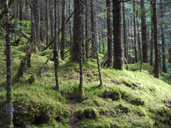
Just about everything about the forest was very different from what I'm used to. The trees were mostly firs of various kinds, and I hardly recognized any of the groundcover plants. Mostly there's moss--moss everywhere, as a spongy carpet and a furry covering over tree trunks, even draped from tree limbs. It's beautiful and strange. As Scott pointed out, there's very little real soil--it was all scraped off by glaciers in the past, so most trees are actually rooted in the moss.


I believe Scott said the trail we hiked climbed to about 700 feet. That's about twice what the highest point of the Norris watershed trails climb to, but it didn't feel all that much higher. There was only one stretch that was really strenuous, and that was because it was stairs...201 stairs. I took a picture once we reached the top. You can't see all the flights since they wrap around the hill, but you get the idea.


We made several stops for Scott to talk to us and answer our questions. At one point we stopped by a little pool with a few lilypads along the edge. I didn't think lilypads liked cool weather, but I don't know much about them. It was a lovely little area. I thought I had a picture of it but I can't find it. Anyway, while we were there Scott found a weird fungus thing called Bleeding Teeth or something like that, and he was delighted. There's a picture of it to the left; I don't know whose finger that was, but I liked that it matches the drops of viscous "blood" exuded by the fungus. Scott said that no one knows why the fungus "bleeds." He also found a yellow slime mold called scrambled eggs, which tickled him completely. He seemed to really like slime molds. (That was not a sentence I ever expected to type.)


We got some glimpses of the glacier as we hiked, but there were lots of other things to see too. We stopped at a waterfall for a while, although I didn't get a picture of it (my camera batteries had died and I was resting them to try to get one or two more shots of the glacier later--it worked, too, but I missed a lot of good stuff in the meantime). After we'd been at the waterfall for a few minutes I started to get too chilly, so I put my hoodie back on. See, I'm glad I brought it anyway!

And here's the glacier, with my brother standing in front of it. (I told him to smile and he said, "I am smiling.")


It was a lovely hike and a lot of fun. And considering how much I ate on the cruise ship, I really needed some exercise. We didn't see any bears, but we saw lots of bear poop in the trail. Scott said that once he was leading a group up the stairs when they came upon a bear coming down the stairs. He had the group move over as far as possible and the bear just walked on by. I think bears are cool, but I am so so so so so very glad we didn't have to share a trail with one.